Lee Hazeldine and Colin Walker describe how using mobile technologies on a field trip is an engaging way of enabling students to record their learning and share ideas.
The field trip is a valuable opportunity to put students’ understanding into reallife contexts. One of the key challenges of conducting a successful field trip is facilitating engagement-rich activities that enhance learners’ experiences, whilst allowing them to communicate and share their ideas. With the development of mobile digital technology come new possibilities that have the potential to transform how students learn. These transformations significantly improve our capacity to differentiate learning and create an inclusive environment in which all students’ contributions are valued. Digital developments allow the creation of networks characterised by ‘diversity, autonomy, openness, and connectivity’ (Downes, 2012, p. 85). By using digital technology, students are increasingly becoming ‘do-it-yourself’ learners ‘… capable of sharing their knowledge and expertise with other individuals’ (Kropf, 2013, p. 13). Online networks provide opportunities to connect with, and reflect upon, the ideas of others. The multisensory format of mobile technology is designed to absorb and blend a range of media, including text, image, video or sound; such potential can enrich students’ experience, reception and comprehension by providing versatile spaces, unrestricted by particular modes of expression, that allow them ‘… to think and design collaboratively and creatively within a community of practice’ (Mills, 2011, p. 2). This format of engagement might therefore allow learners to benefit from divergent viewpoints that deepen their critical appreciation.
In this example, geography and religious education PGCE students were taken on a field trip to Aylesford Priory in Kent. The purpose of the visit was to get students thinking about
the creative potential of cross-curricular field trips for learning; the students were challenged to generate resources and strategies that would engage key stage 3 learners across both
disciplines. Furthermore, this activity required PGCE geography students to consider the key stage 3 curriculum with a particular focus on the relationship between human and physical
geography and geographical skills for fieldwork. The site provided ample opportunities for exploring how human intervention (population, international development and economic activity) and physical processes interact to influence and change landscapes; it showed how conclusions can be drawn by using data collected from contrasting spaces – in this case, the different locations on the priory site. The activity also modelled how digital technology can be used as an educational resource for learning.
Online Interface
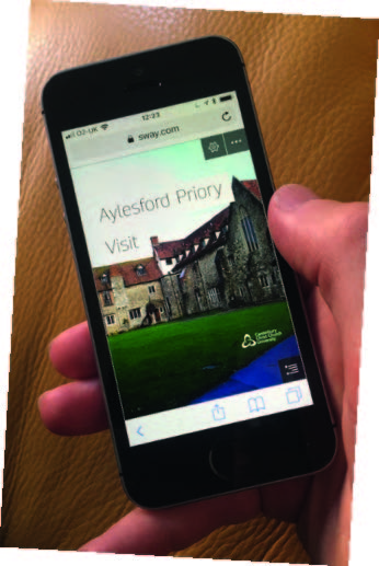
Students were given an online interface (Figure 1) to explore the environment using their mobile devices. The interface provided instructions, tasks, collaborative spaces and facilities for
recording and reviewing learning. This format of engagement was intended to provide a rich, multisensory space that piqued students’ curiosity, whilst allowing opportunities for instantaneous cross-fertilization of ideas.
The online interface was constructed from applications that satisfied a range of contemporary learning requirements: versatility, cost-effectiveness, replicability and inclusivity. It was developed from freely available online resources that any teacher could use without the need for high levels of digital literacy. The resources selected provided a versatile range of opportunities that went beyond traditional classroom-based environments. Participants could also instantly interact without restrictions of time or place. In addition, the interface was designed to be easily reproducible, allowing the strategy to be efficiently applied to other learning sessions. Since the advent of Web 2.0 technologies, combining applications to produce a seamless online experience has become simple.
Figure 1: Online interface. Photo: © Lee Hazeldine.
In this instance, the online resources used and incorporated into the interface had the following functions and benefits:
- Microsoft SWAY, which provided storyboards that displayed and incorporated a range of media, whilst being seamlessly adaptable to a variety of devices (e.g. phones, tablets and desktops). The application also allows collaborative editing and can be instantly revised and adapted to changing circumstances.
- Padlet, which provided the mechanism for students to add and share a variety of multisensory content (images, video, text, drawings, audio). It was also a means to collaborate, discuss and review learning. Padlet spaces were incorporated into SWAY by simply pasting the given embed code into its storyboard.
- Google Maps – the simple production and inclusion of a bespoke Google map allowed students to orientate to key locations. The interactive nature of online maps allowed students to access contextual information about each site. Google Maps can also be easily embedded into SWAY.
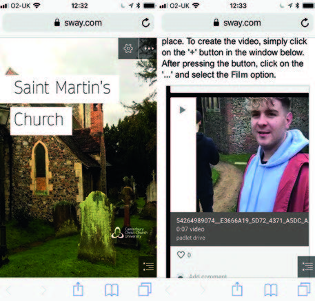
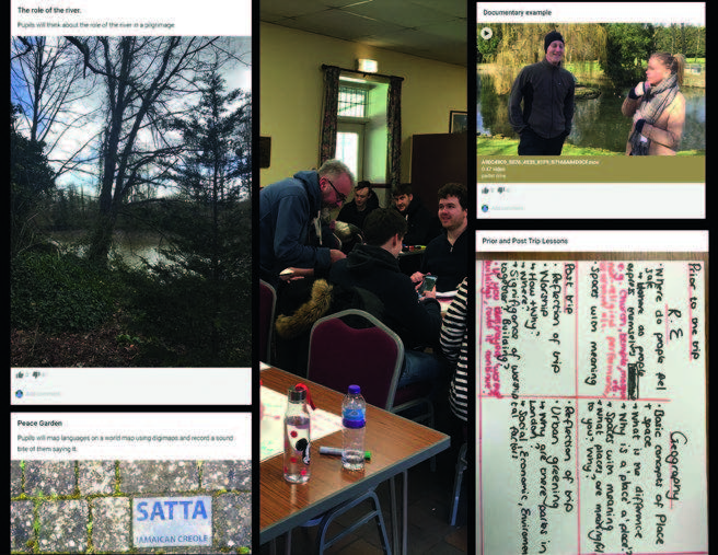
Before the field trip the effectiveness and usability of the interface had to be ensured, so students were asked to engage with a prototype (Figure 2), which identified both the benefits of the strategy and opportunities for improvement. The online resources worked well across all platforms – the interface was easy to use and students made a range of contributions using a variety of media.
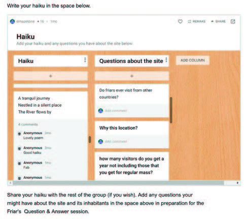
On the day of the field trip, students were given access to the online interface that equipped them with maps, instructions, collaborative spaces and an itinerary. The first task required groups of students to quickly explore the environment and write a haiku poem based on their impressions – this gave them an opportunity to review and share their initial perceptions of the space (Figure 3).
Figure 2: The pre-session prototype. Photo: © Lee Hazeldine.
After reviewing their haiku poems, students were instructed to record objects and events around the various geographic locations and generate a field trip strategy they could use to engage their own pupils. To support this, the interface included a stimulus section with a range of existing geographical strategies and concepts that could inspire the students’ own ideas, without the need to access physical library spaces or notes generated in classroom settings. The collaborative spaces also enabled tutors to edit and monitor responses, ensuring their appropriateness and relevance for learning. By constructing and questioning geographic knowledge for themselves, the strategy also demonstrated that geographical understanding cannot be neutral; it depends on the questions and viewpoints that shape it (Roberts, 2013, p. 18).
After completing the learning activities the students reconvened to review the ideas collected. Each group of students presented their ideas online to the other groups and received instantaneous critical and evaluative feedback. The review provided a rich network in which a plethora of ideas in a range of media could be shared and discussed (Figure 4). The virtual spaces allowed tutor and student to review everyone’s engagement with learning at any point and receive instant critical feedback, which significantly improved their capacity to review the impact of learning compared to classroom-based sessions. This also has the advantage of allowing learning to be revisited during future sessions and can be a great way of evidencing progression.
Figure 3: Collaborative online haiku and discussion.
The critical dialogue that was manifest within the virtual learning environment clearly demonstrated that students had gained a wider appreciation of the learning possibilities of a field trip. The dialogue on this field trip also demonstrated the connections between religious practices and human geographic interventions, which provided insight into cross-curricular learning opportunities. For example, some students had noted that the priory used the river both as a source of food and for religious ritual (pilgrimage); these aspects were, in turn, incorporated into proposed learning activities. Another suggestion was using the different languages inscribed on stones in the Peace Garden to generate an activity in which students located their origins on a world map, highlighting both the different belief systems and the geographic features of the different locations.
After evaluation and amendment, these strategies were incorporated into their own field trips for key stage 3 students. Archived online, they provided a legacy of strategies to inform future teaching and learning.
A survey conducted at the end of the session found that 92% of the students thought their ability to connect with others online enriched their own learning; 86% that the digital strategy enhanced their capacity to express their ideas; and 78% that it provided an opportunity to deepen their understanding outside of the classroom.
Figure 4: Reviewing learning ideas on the interface. Photo: © Lee Hazeldine.
Summary
Using an online mobile strategy on field trips has many advantages. By encouraging them to share ideas and become active partners in learning, the strategy allowed students to widen their understanding of the relevance of geography to a location and to consider how this understanding might connect with other disciplines. The multisensory nature of the technology also provided opportunities for students to capture their ideas in ways that suited their preferred modes of learning. By recording the impact of learning, the strategy enhanced opportunities for reflection and formed a legacy for the development of both teaching methods and cross-curricular interventions.
Lee Hazeldine and Colin Walker are Senior Lecturers at Canterbury Christ Church University.
Email: lee.hazeldine@canterbury.ac.uk
References and further reading
Downes, S. (2011) ‘“Connectivism” and Connective Knowledge’. Available at: https://www.huffpost.com/entry/connectivismand-connecti_b_804653 (last accessed 29/03/2019).
Downes, S. (2012) Connectivism and Connective Knowledge: Essays on meaning and learning networks. Ontario: National Research Council Canada. Available at: https://oerknowledgecloud.org/sites/oerknowledgecloud.org/files/Connective_Knowledge-19May2012.pdf (last accessed 29/03/2019).
Kropf, D. (2013) ‘Connectivism: 21st Century’s New Learning Theory’, European Journal of Open, Distance and E-Learning, 16, 2, pp. 13–24.
Mills, K.A. (2011) The multiliteracies classroom. Bristol: Multilingual Matters.
Roberts, M. (2013) Geography Through Enquiry: Approaches to teaching and learning in the secondary school. Sheffield: Geographical Association
 PRISM
PRISM Jack Charter
 1589
1589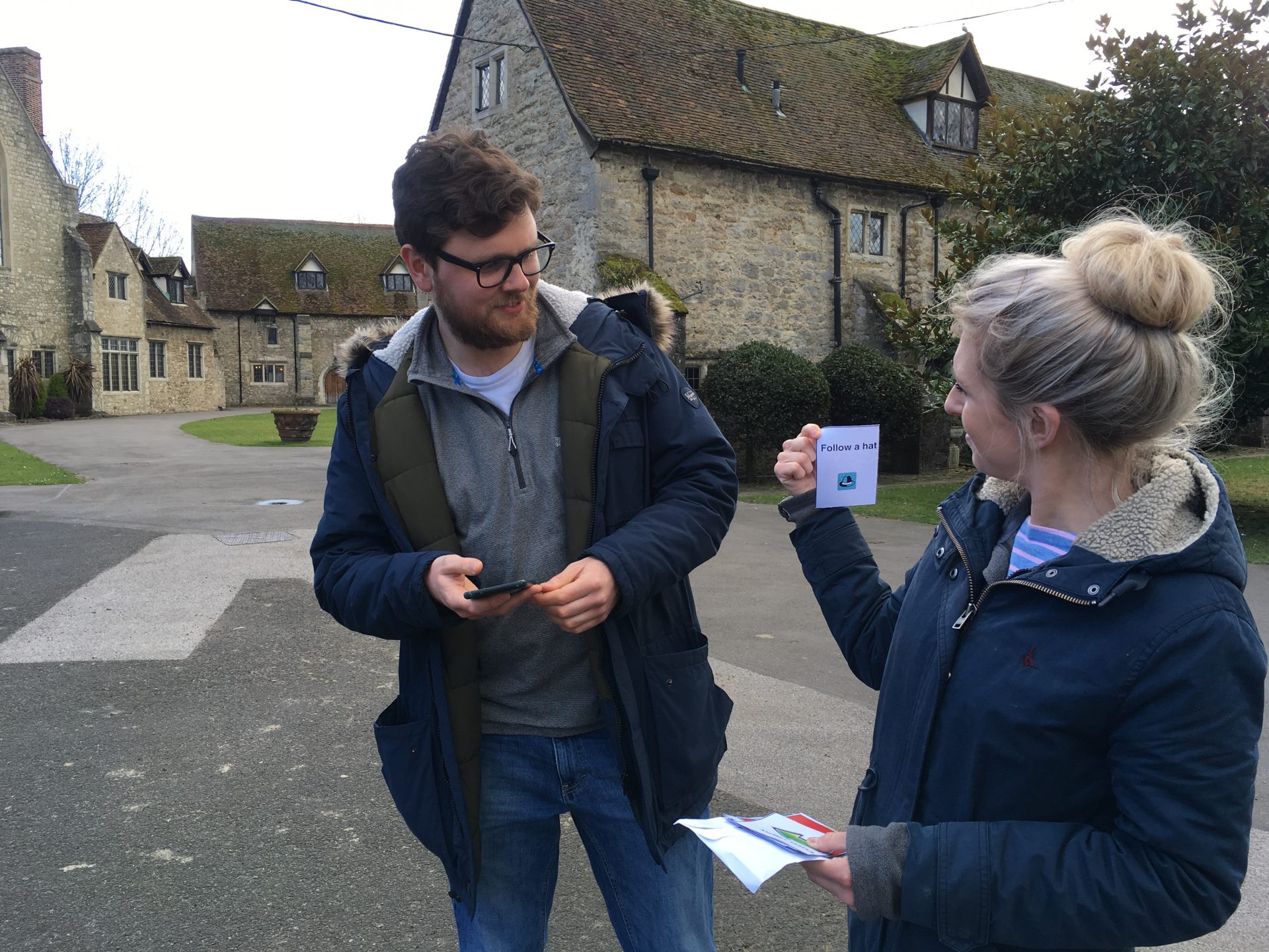


This is a really interesting study. Thank you for sharing.